
Seeing The Old As New Again
- Apr 8
- 8 min read
It's been a while since I've posted on my website. I had a little health scare last summer and that limited my ability to journal and write. It didn't prevent me from wondering the back roads, but I couldn't easily capture my trips. There was a day trip to visit Cannonball Bridge south of Vincennes. I have monthly trips to northeastern Indiana to work with the Engage Noble Leadership Academy and have nearly exhausted every route that I can take to get back back-and-forth to Noble County. I planned a personal retreat to Saint Mary-of-the-Woods College near Terre Haute in January. There was a speaking engagement with the Newton County SWCD in Kentland. But I haven't written about it, just wandered, posted a couple pictures on Facebook. When people learn of my travels, they typically ask, "Have you been to _______?" I get it, but a more interesting question is "When were you last there and what do you remember?"
In choosing a destination for this trip, I decided to retrace part of our last journey when we completed our goal of visiting every city, town, and village on Indiana's map. In November 2016, Beth and I had mapped out a day trip route to visit the last unvisited sixteen dots. We started in Ripley County then through Dearborn County to Aurora. We followed the Ohio River through Ohio and Switzerland counties to Vevay recalling earlier trips here. The sun broke throught the clouds we sat on the banks of the Ohio River. We then headed northwest into Jefferson and Ripley counties. We got lost, burned a lot of daylight, drove through towns in the dark, and finished in Friendship. We were overjoyed, relieved, and, of course, Beth had enough for sight to prepare for this moment. It was one of my best wandering trips and worthy of reliving some of that day.

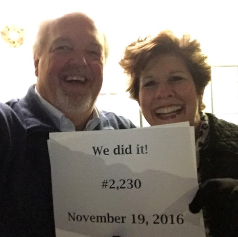


Celebration at the Friendship, Indiana Post Office Ten Years Later - 2026
It was Easter, a wonderful celebration and the music is amazing. Because I sing with the church choir for Easter Vigil Mass on Saturday night, I can sometimes wander on Easter Sunday. I set my sights on southeastern Indiana all the way to Madison on the Ohio River and back home. It was cold this morning -- 42º and 15-20 mph winds. Packed up my picnic cooler, stopped at the cemetery to place, beautiful yellow flowers on Beth's grave and then on to the interstate highway to Shelbyville. The cool temperatures and the early Easter observance meant that the trees really weren't blooming yet.
Drove through town to my first stop, Geneva, in southern Shelby County. On my last visit in August 2021, there was a Low Dam crossing the Flat Rock River here. In 2025, the dam was removed by the U.S. Fish & Wildlife Service. All that is remains is the artificial waterfall. It was the first of many sites that had changed over time and it was interesting to look back at earlier travels.


The Flat Rock River at Geneva -- Low Dam (2021) after removal (2026)
Turned south and followed the river, a short distance, then headed to Hartsville on State Road 46. My destination was Anderson Falls, a Bartholomew County Park. I crossed a wrought-iron bridge before arriving at the Falls. My first time visiting was 2015 on a cold winter morning and the stream was completely frozen over. This time, the stream, Fall Fork of the Middle Fork of Clifty Creek, was easily visible and not yet hidden by foliage.

Anderson Falls, Bartholomew County Park, Hartsville
Continued south through Grammer then in stopped in the road, capturing picture of a stone arch bridge over Nettle Creek. Passed through farm fields awaiting the hum of tractors and planters as they put another crop in the ground this spring. But I was entering the area where the fairly flat fields were giving away to rolling hills all the way to the Ohio River. Arrived to Scipio and stopped to take pictures of its covered bridge over Sand Creek.


Stone Arch Bridge over Nettle Creek Scipio Covered Bridge over Sand Creek
On a lark, I discovered a historic marker for the Kellar Grist Mill north east of North Vernon. There was a marker on the roadside adjacent to the ruins. It was hard to capture good pictures, but a topographical map shows how the natural loop of Sand Creek created a site for the Mill and its race. It goes to show that there's always something new to explore.


Kellar Grist Mill Historic Marker and Ruins

I took a brief visit to the Vernon Cemetery, where my great grandparents, great-great-grandfather, and many relatives are buried. Road construction, diverted me on to SR 3 rather SR 7 to Dupont and on to Madison. I learned that the road was actually closed entering Madison. I navigated around the bridge site and went looking for Hanging Rock on SR 7 between 'North' Madison and old Madison. When I arrived, there were already two people parked to take pictures.
Arrived at Madison, a beautiful city nestled between the Ohio River and the bluff. The entire city is a designated historic landmark and district. In the '60s and '70s when cities all over the country were taking down their buildings in an effort to "modernize," the city didn't have the resources to replace their structures. Instead, they reinvested in their buildings and made their community an amazing place.

The James FD Lanier Home/State Historic Site is a showstopper. Lanier was an entrepreneur and financier who helped the State of Indiana repackage public debt to avoid bankruptcy. During the Civil War, he stepped up again and loaned the State of Indiana $1M to stave off creditors and outfit troops. I've been here many times, but I don't get tired of seeing it. I have visited the interior of the home on a few occasions as well. I'd planned to have my picnic lunch on the a park bench on the riverwalk. The sun was out, the air was cold, the breeze was stiff. It wasn't ideal, but that wasn't going to stop me today. I had to make sure that things didn't blow away, and I could only have one item opened at a time. It wasn't leisurely, but it was memorable!
I drove away from the riverfront and across Main Street to the Broadway Fountain. I have a memorable picture of our girls sitting on the fountain on a wandering trip when they were young. I messaged to see if they remembered and they did. I captured several pictures of the fountain and the adjacent Trinity UMC Church.


Ohio River Walk Trinity United Methodist Church Broadway Fountain in Madison
Took US 421 to the hilltop of Madison on SR62/SR56. Instead, I drove east on old State Road 62 and learned why they constructed a new route. It was winding, undulating, and required guard rails for safety. I was returning to Manville where I got lost trying to find it in 2016. I readily admit that I've only been lost twice in my life and one of them was on our trip to Manville. I passed the Manville church where we photographed years ago. Today, I stood on the bridge over Indian-Kentuck Creek and took a picture of the rapids downstream. Then photographed a vacant building that had been a community gathering spot years ago.


Rapids on Indian-Kentuck Creek and Former Store in Manville
The China-Manville Road followed the stream through the valley to China on SR 62. On our first trip, we arrived in China at nightfall. There was a church building lit up, but we didn't see any signs. Today I took pictures in the daylight of the Shepherds of Christ Ministries in a former Saint Anthony Catholic Church building.


Church building and Road Sign, China
I was very, very curious about this next dot on the map -- Canaan. When we arrived, it was pitch black so we didn't know if there was anything to see or not and we were running out of time as well. THat night, there was an intersection with two street markers and I stopped for a picture. I was back 10 years later, I driving through town. I captured pictures of the Canaan Academy (housed in a former elementary school building), the Masonic Lodge, and the fire department. I also went searching and found the street markers from that day.


Masonic Lodge, Street Signs, and Volunteer Fire Department, Canaan
A few miles up ahead, I stopped to see a stone memorial and burial marker for Chief White Eye.

A Wyandotte chief killed by white settlers after the Pigeon Roost Massacre in 1812, age 30 years. Grave was first hidden up White Eye Hollow and relocated in 1965. White Eye was over 6 feet tall, wore long black hair, buzzard, quills, breach cloth, confederate leggings, and blanket over his shoulder. He bred horses for early Jefferson County settlers with his stallion black eagle.
The marker in a private yard on the west side of SR 62 just north of the intersection with SR 250. On the state map, SR62 is designated Chief White Eye Trail.
There were still two more stops. But today I did them in reverse order. Turned off the highway at Cross Plains and took a looping route into Friendship. I had never driven where the National Muzzle Loading Rifle Association holds its National Shoot every September. It is a big deal and people travel from all over the country to attend. I photographed the organization's headquarters/historic Rand House. On Main Street was the Post Office and Friendship Tavern where we ate dinner that night after our successful trek.


Rand Historic House/NMLRA HQ Friendship Tavern in Friendship
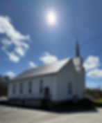
Took SR 62 west and crossed SR 129 and traveled country roads to find Benham UMC, which was the next to the last place we visited on our 2016 trip. On that night, the church was lit up like a beacon in the night and on this Easter Sunday the sun shown brightly in the sky.
Benham United Methodist Church, Benham
I continued to New Marion and turned north on Old Michigan Road, the first north-south state 'highway' in Indiana. There was a local historic marker along the roadside. Continued through Dabney to Napoleon. The historic route met with the modern route following US 421. It was a beautiful day with fluffy clouds and blue skies. I took pictures of several structures -- St. Maurice's Catholic Church, St. John Lutheran Church, Kremer House, former Napoleon Flour Mill (Home of White Lily Flour and Pure Buck Wheat Flour), and a historic marker for Berry's Trace, a early pioneer road running east-west across Indiana.
Napoleon -- St. Maurice Catholic Church Napoleon Flour Mill


Berry's Trace Marker Stone Arch Bridge over Vernon Fork
Traveled west on Millhousen Road and stopped to look at a stone arch bridge over the Vernon Fork of Muscatatuck River. In the early '80s I sold fertilizer for Arcadian Corporation and this was the home of Smith Brothers Feed Mill and Larry Smith, one of my early customers. I knew the Mill was gone. I knew where Larry and his wife Becky used to live, but times change.

I drove past their house, then turned around and spotted some neighbors in their driveway and asked if they were still there. They were kind enough to phone them and they were open to a visitor. I stayed with Larry and Becky and their family for about an hour and a half. What a treat!

My last pictures of the day were in Millhousen and included the Knights of St. John Hall, St. Aloysius School and Immaculate Conception Catholic Church whose steeple towers over the surrounding community. I was finished. I drove to and through Greensburg hopped on to I-74 and sped home.
I try to teach students that every trip is a different experience. Places change. Seasons change. We change. Who's traveling with us? What are the circumstances? And what are the experiences that changed you since you last visited? To being a successful wanderer, is to be curious and grateful.
So I wander as often as I can, alone or with others. I always celebrate wonderful memories traveling with Beth. I need to spend time on the road, out in rural Indiana, exploring new sites, or reminiscing. It's all part of savoring Life Off The Highway.
U.S. Fish & Wildlife Service