
An Easter Egg Hunt for a Wanderer
- May 23, 2025
- 7 min read
When I was kid I always enjoyed finding real color-dyed eggs and, since we had chickens, eggs were not a problem. I also enjoyed the plastic ones filled with chocolate and candy. Now that I am older, I still enjoy the hunt but the ‘find’ is different. I am searching for experiences that matter.
On this excursion into western Indiana, there were four primary targets with a mixture of new and old - Gopher Hill Cemetery, revisiting Portland Arch, Rob Roy Covered Bridge, and Black Rock Nature Preserve. But first, I had to get there!

I grew up attending Manson Congregational Christian Church, a small country church with one Sunday morning service and 70-80 weekly attendees. I married Beth in 1983 and she was raised Catholic and attended large churches with many services every weekend. We attended Catholic Church together and I later converted to Catholicism (my choice) and we also sang with the choir (which I still do). Again this year, the choir at St. Pius X Catholic Church sang at the 2-3 hour Easter Vigil Mass on Saturday night which left me free on Easter Sunday.
My family and Beth’s family were scattered for the day and I took advantage of the circumstances and plan a day for wandering. Woke up at 7 a.m. and accomplished a number of chores and was on the road within two hours. I didn’t think about places being closed because I had celebrated Easter the night before. Drove to Costco for gas but it was closed due to the holiday. I left Indianapolis driving north on Lafayette Road past Whitestown and then got on I-65. Fueled up in Lebanon and the headed west on SR32.
When I got to Dover, the road had barricades and warned of a bridge out ahead. I continue on to Shannondale and then made big loop through the country and returned to SR 32 at Smartsburg. Drove into Crawfordsville, turned onto US136 and proceeded west. Took several photos as I drove through Waynetown, Hillsboro, and Veedersburg.


(top row left to right) In Waynetown, the Methodist Church and the former Knights of Pythias Lodge. Ahead in Hillsboro, the Methodist Church. In Veedersburg along US136, a former church building and two buildings catty corner in the ‘downtown.’
Continued to Covington, the county seat of Fountain County. I remembered when Beth and I stayed here at the Garden Gate B&B with package we had purchased at charity auction. I drove around town and took pictures of the courthouse, pictured below. Today I was unable to enter, but it has beautiful murals inside:
This building has multiple murals, including two by Eugene Savage entitled “The Receiver of Taxes,” “The Disbursement of Tax Dollars” and an unnamed mural. They were created 1937, likely with funding from the Federal Art Project. The building also contains several other murals painted by different artists (including the unnamed mural pictured here), all under the supervision of Savage and composed between 1937 and 1939. Covering 2,500 square feet, they “depict scenes from the European discovery of America through the settlement of western Indiana” (Indiana Business News) https://livingnewdeal.org/sites/fountain-county-courthouse-murals-covington-in/

Was looking for a lunch place, but most things were closed. In the meantime, I took a lot of photos of other buildings — Covington Building (now a credit union), Methodist Church, Library, the former Fountain Trust Company building (now a law firm), St. Joseph Catholic Church, and the House with the Lions Antique Store (former Knights of Pythias building) on the courthouse square. We still have items purchased from that store. I settled for lunch from McDonald’s drive-thru. Not my plan!


Continued west on US136 and turned north at the dot for Foster. Zigzagged 3.5 miles to Gopher Hill Cemetery, the first designated stop of the day. Off in the distance I spotted the grain elevator and ag supply center in State Line City on the Indiana-Illinois boder. Pulled in, parked, and ate lunch in the quiet. The sun was out so I opened the door and windows. Stayed for a bit then circled around to get pictures of the two markers — one for the Potawatomi Indians Trail of Death and the other for Harrison’s march to Prophetstown.


In Gopher Hill Cemetery there are two markers - 1) Harrison's Trail - Wm. Henry Harrison's army camped one mile southwest of here at the Old Gopher Hill Cemetery on Nov. 3, 1811 and Nov. 11, 1811 in route to and from the Battle of Tippecanoe. Several soldiers injured during the battle were buried there. 2) Trail of Death - On September 15, 1838, about 860 Potawatomi Indians Camped near here on the forced removal from Indiana to Kansas. They had to camp by a dirty stream. Two small children who died on the trek from Williamsport were buried at this camp.
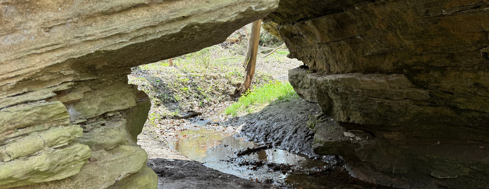
Returned to Covington as I had to get back on the east side of the Wabash River and then headed north on Portland Arch Road toward my second targeted destination — Portland Arch Nature Preserve. It had been 43 years since I was last here, although I had encouraged others to visit. This preserve is a designated a National Natural Landmark and is home to one of only a few natural arches in Indiana. There were two other vehicles in the parking lot for the North Trail. I signed in at the entrance station and then followed the trail downward from the upland, through the terrace, and finally to the creek bed. Took several pictures on the way to the Arch. The preserve encompasses the wooded valleys, ravines and rocky cliffs around the lowest section of Bear Creek, which flows northwest toward the Wabash River. The actual Arch, which is in the first third of the circular trail, was created through the Mansfield Sandstone by Bear Creek, undercutting the bluff on both sides. The sandstone was strong enough that it did not collapse. The Mansfield Sandstone is from the Pennsylvanian Period, some 230 million years ago. I took photos on each side of the Arch and it is amazing to see how small the arch looks compared to the massive stone bluff which surrounds it. As I taking pictures of the Arch, another hiker came through and I learned that he was from Watseka, Illinois, and visits here 2-3x per month. I continued on the trail alone through the creek’s valley and took many more pictures. The redbuds were starting to bloom, the mayapples were covering the forest floor while the sandstone bluffs hemmed in the valley. The sun was out and it was only 60º, but the temperature felt 5-7º warmer in the woods and there was no wind. This slideshow shares views on the North Trail hiking to the Arch and views of Bear Creek Valley beyond the Arch. The panoramic photo shows the hole in relation to its Mansfield Sandstone bluff from the other side.


As I left Portland, I spotted the old school building which had been restored as a house. Years ago, it was an antique shop when my mother joined Beth and me in Spring 1982 when we were just dating. By this time everyone else had determined that we shold get married but we had only been dating six month! I recalled visiting the shop together and cherishing that time early in our relationship. The road heading east would take me to the next destination, Rob Roy Covered Bridge. I took a route that would let me enter from the west. The bridge is vehicle accessible and crossed over Big Shawnee Creek.


After that I drove into Attica. This town has beautiful homes lining its streets and I took several pictures of churches and public buildings. (Top row)Art Deco National Guard Armory, Attica Williamsport Evangelical Presbyterian Church, (Middle) St. Francis Xavier Catholic Church, Carnegie Library with 'Spirit of the the American Doughboy' statue, (Bottom) The Sanctuary in Attica Bed & Breakfast (in a former church), First Methodist Church.


Took Perry Street which became Riverside Road several miles to Riverside. Crossed the Wabash River to Independence and then NE on Independence Road. Arrived and entered Black Rock Nature Preserve, a 45-acre state site protecting a portion of the very rare sandstone/ siltstone barrens. The southern exposure combined with the thin acid soils slows the growth of trees on the site. Black Rock is a prominent Mansfield sandstone outcrop rising over 100 feet from the Wabash River. There are no comparable outcrops for a hundred miles in either direction down the Wabash River. The promontory is very short and easy walk from the parking area. This particular spot was used by Indians to track movement along the river route. I took several pictures and sat on a rock taking in the view and the moment. Beth’s siblings were engaged in a substantial text thread. I finally weighed in and mentioned I was wandering with Beth on my mind. She and I had not ever visited here.


(Clockwise) Theview of the Wabash River upstream, the Black Rock promontory. the view downstream - 100' below, and a picture on a windy perch.
As I left, I called a dear friend who lived very near Black Rock. I agreed to meet him on a family farm near Montmorenci. We visited by the cattle barns, then took the Gator out for a drive across hilly grazing pastures and along a winding creek. It was a good way to finish the day.
Today, I journeyed along historic highways through prairies, explored villages, and hiked nature preserves. I walked under the Arch and followed Bear Creek through its valley, shaped over millions of years. I traced the Wabash River upstream to an incredible overlook. I delved into history at a cemetery, revisited a covered bridge, and pondered the stories of numerous homes and buildings in small cities and towns. There was even an unexpected visit with a dear friend. Life Off The Highway is a hunt of its own. And, you never know what you'll find to see and do, but memories are there for the making.


Comments