
Seeking A Roundabout in Rural Indiana
- Sep 19, 2021
- 6 min read
Last Friday was our 38th Wedding Anniversary and like many previous days, it seemed appropriate to wander rural Indiana. It was enough just being alone in the truck with Beth's spirit. The hardest decision was which direction to go. Since I've been to every dot, the goal needed to be something a little different.
The route was somewhat pre-determined because I needed to to make a late afternoon visit to a funeral home in Monticello where a friend's father was being celebrated and remembered. So I could go west, northwest, or north central. I prepared to visit Black Rock Nature Preserve in northeast Warren County, along the Wabash River, downstream from the former Indiana 4-H Center. There was also an anomaly in the area I wanted to revisit from more than 30 years ago, the cemetery with a 'roundabout' in rural Warren County, west of Lafayette/ West Lafayette. I could have wandered on my way there, but a lot of roads are familiar in this area. I've wandered them for FFA, 4-H, Callahan Seeds, Corn Growers, Beef Cattle, Rural Development and pleasure.

By the time I got a few tasks done at home I hit the road close to 10am. After a couple of errands, including gas(!), I headed toward Purdue. I made sure I had a number of downloaded podcasts in my Spotify library for the day’s travels. Went west on SR32 to US421 to SR47 to US52. I was texting with Dr. Ron Lemenager, a Purdue Extension Beef Specialist and long-time friend, and was hoping we could connect for lunch, and we did.
The only change from my normal backroads route to Purdue was a side trip at Monroe on US52 into Stockwell. Farmers aren’t harvesting all out, but it is getting close. The private elevator at Stockwell was busy. Across the street was the Knights of Pythias Castle 1906 (KofP) with a ugly sky blue painted facade across the front of the entry. There’s the Sidewalk Cafe on the corner and the next building was the IOOF Hall although its tablature reads IOOF Block. It houses the modern ‘Stockwell Market’ on the first floor.
I could have easily taken Stockwell Road north then turned onto CR800S, the main route, and headed west. Instead I drove due west on CR900S until it T’ed at the non-existent village of Concord. Then I jogged north to CR 800S at the intersection by Wea Creek. I drove that for a few miles then turned north on CR100E and drove to Veterans Parkway before turning west again to reach US231. I arrived on campus right on time to pick up Ron. We crept through campus along State Street and down to the levee. That stretch hasn't changed as much as other places on campus. We ate on the patio at Nine Irish Brothers and enjoyed Pork Tenderloin sandwiches and Iced Tea, and good conversation for nearly two hours. Very attentive service as well. Drove back to his office past the new Vet School complex and dropped him off.

Returned to South River Road and drove that road for the first time in forever. Stayed on it past Fort Quiatenon and the road to the former 4-H Center. Black Rock Nature Preserve was now off the agenda due to time constraints. That could wait as I thoroughly enjoyed my time with Ron. Continued west into Warren County, entering the small village of Green Hill. Took a picture of the former Masonic Lodge in town and then continued west, although this road wasn’t straight at all, winding along Little Pine Creek. After an unusually large jog in the road, the topography flattened and returned to rolling productive farmland. I began to notice concrete posts again and took some pictures. Continued west until the road T’ed a mile south of my destination. This is what the roundabout looks like on Google Maps.
Mound Cemetery is a good-sized cemetery with a gravel road around it and four axes going each cardinal direction. It’s hard to grasp the size with photos, but it's not small. A farmer was cutting hay in a nearby field. I took pictures around the perimeter and drove to the top of the cemetery and took pictures each direction. Saw a few familiar family names on stones near the peak.


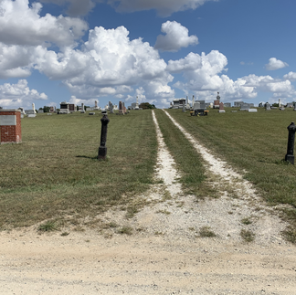


(Clockwise) Approaching Mound Cemetery from the south, front entry from the west, looking south, looking east, looking west, looking north.
From here I headed back south, then west to Independence-Pine Village Road. A mile north was the dot for Chatterton, but there is nothing there except a three-point intersection. I continued into Pine Village after joining SR55 south of town.
It was a beautiful day to be wandering. The skies were autumn blue with white clouds dancing to the horizon. Summer's green was giving way to Autumn's multi-colored palette. If you drive with the windows down, you can hear the wind rustling through the dried cornstalks waiting for farmers to enter the fields and harvest their bounty. On my routes, I can choose to go fast or slow and no one is around to care. I'll even wave people around so I can be alone. In Pine Village, I took pictures of the Pine Village Football historic marker, the old McCormick-Deering farm equipment dealership, the Knights of Pythias (KofP) Hall from 1900, a caboose from the Monon RR, the Christian Church, and the Bible Church.


Listened to a podcast interview of Krista Tippett and Ellen Langer about Science of Mindlessness and Mindfulness. It is not about practices and rituals but better noticing. Very good insights. This is also the key to enjoyable wandering - curiosity and noticing.
Headed north on SR55 to Oxford in Benton County. Came across the former school and park, a beautiful old church, the Messner Block/Masonic Lodge building, the KofP building now serving as a bank, and the newer Masonic Temple around the town square. Oxford was the original county seat until Moses Fowler ‘paid’ to have it moved to his town of Fowler. Just off the town square was the Public Library and back south was the Methodist Church. Driving north on SR 55, I came to US52. This is Atkinson, another agricultural stop on the railroad, on the south side and Benton Central High School and an elementary school on the north side.


(Clockwise) Oxford School, church in town, first Masonic Lodge, KofP Castle, second Masonic Temple, public library.
Crossed US52 and headed north for two miles then west to the former Benton County Poor Farm, the structure is now serving as apartments. Back on my main route, I continued north through the massive wind farm heading to a spot in the northeast edge of the county. Stopped and took pictures of an old abandoned church and finally arrived at Mount Gilboa, the county’s highest point at 800 ft. above sea level, compared to the state’s highest peak of only 1,257 feet. It’s on CR600N between CR800E and CR900E.


(Clockwise) Former Benton County Poor Farm, abandoned church in Benton County, looking west from Mount Gilboa, looking east from Mt Gilboa, wind farm, wind farm.
Nothing marked, nothing special, but I took pictures to the east and west from here. I turned north toward Remington in southern Jasper County. Although I have pictures, it is hard to grasp the expansiveness of the wind farms. With the naked eye, you can spot the jumble of turbines in the distance, but cannot replicate it on a phone's screen.


It’s easy to spot Remington with its towering grain silos standing tall in the prairie. The former Farmers Cooperative Elevator is now owned by Co-Alliance Co-op. I drove through town and took pictures of a former church turned residence and the restored Remington Depot which is a lovely park by the railroad that intersects town. I also captured the modern library, the historic water tower, and Sacred Heart Catholic Church.
I traveled east on US24 through Wolcott and Reynolds before arriving in Monticello. After the visitation, I headed home, traveling east on US 24. Drove through Idaville, Burnettsville, Lake Cicott, Kenneth (at France Park) and turned onto US35 on the west edge of Logansport. Skipped town and headed south on SR29/US421 and took the familiar route to 146th Street and US421 near Carmel. Went to some friends' house for dinner and the evening.
Friends are critical on my grief journey and today that was especially true. Grateful for caring spirits. It was a successful day of wandering and noticing -- remembering and missing Beth.


Comments